Courses Resources and Student Mentoring
Home Page:
Active Tectonics, Active Landscapes and Human-Environment Interactions
Teaching
Research Projects
Resources + Opportunities
Toke CV
This page is a work in progress, for now...
While most of my class materials are delivered in person and using CANVAS below are some activities that I have constructed and might be useful to students and educators outside of UVU:
Mapping Plate Boundaries with Digital Hillshade Maps, Volcanoes, and Earthquakes (All Ages)
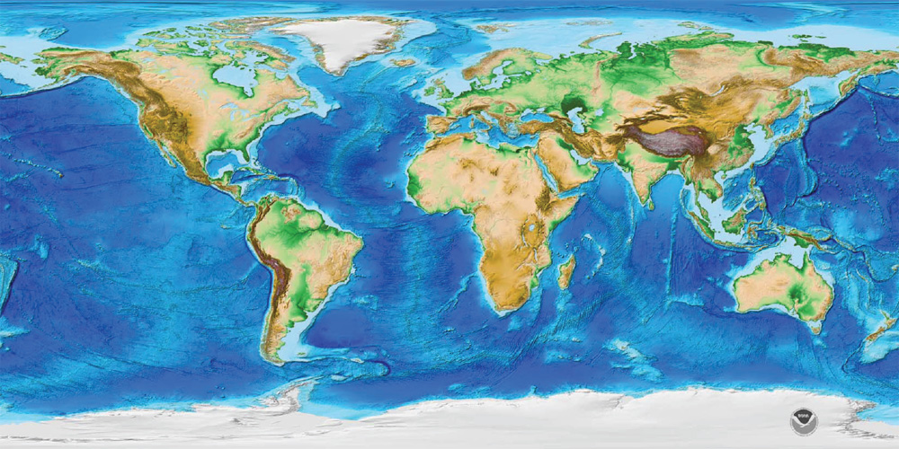
As a part of Arizona State University's NSF GK-12 Fellowship Program I used GIS to create a set of high resolution maps that students K-College age could use to identify and map the major plate boundaries of the world.
This set of maps is presented in .pdf format and contains an overview as shown above as well as three maps (hillshade only, hillshade + volcanoes, and hillshade + earthquakes) for five regions of Earth (The Carribean and Atlantic Ocean, Western North America, South America and the Southeastern Pacific Ocean, East Africa/Himalya/Indian Ocean, and the Western Pacific).
This link is a .zip file of all of the maps and suggested lesson plans for K-12 educators: ZIP LINK
This link is a .pdf file of only the maps: PDF MAPS LINK
This link is a quick activity that I have my 1010 Geology Students do in the second week of class: ACTIVITY LINK FOR PHYSICAL GEOLOGY
Maps were created using ArcGIS or Google Earth. Topography comes from NOAA ETOPO1 Global Relief Map.
Locations of active volcanoes are from the Smithsonian Global Volcanism Program.
Earthquakes shown on Google Earth Maps are from USGS catalogs for 2010 and 2008 (all earthquakes for those years).
Similar maps could be created without ArcGIS just using Google Earth and these data sources for different years. Note that these maps can be printed at 11x17 scale and laminated for reuse class after class.
Designing a Fault Crossing (K-8 level activity)


This lesson was also made as a part of Arizona State University's NSF GK-12 Fellowship Program in 2010. I worked with my teacher partner Ms. Johnson from the Peoria, AZ school district.
Our aim was to allow 6th-8th grade students to work on the real life problem of fault crossings for major life lines. Consisting of a power point discussing earthquake scenarios and fault motions the students are tasked with brainstorming ways to bring infrastructure across fault lines without the infrastructure failing in a big earthquake.
We gave the students play dough and other supplies to create their own socio-enviornmental landscape with infrastructure and geology (had to be a major fault). Then we would test their play dough landscapes as the teacher earth movers. Finally the lesson wrapped up with the successful story of the Denali Fault Oil Pipeline which was engineered to withstand earthquakes and did not fail in the M8 earthquake.
This link is a .zip file of all of the lesson plan material for K-12 educators: ZIP LINK
This link is a .pdf file of previewing the lesson a bit more: PDF LESSON PREVIEW
This link is a .docx file describing the lessons (this one and the one above) and the K-12 AZ science standards they cover: Lesson Science Standards
Note that this fault crossing lesson draws heavily from USGS (i.e., This Pub ) and the California Shakeout Scenario.
Direct questions to: Nathan A. Toke
last updated on
March 15, 2019